Since its establishment in 1975, the Northern Territory Emergency Service (NTES) has been instrumental in responding to numerous significant emergency events including tropical cyclones, floods, earthquakes and storms across the NT.
As we mark half a century of dedication, service, and life-saving missions across the Territory, we’re looking back at the moments that define us and helped shape the service over the past five decades.
Cyclone Tracy
Cyclone Tracy tore through Darwin on Christmas Eve 1974, claiming 66 lives and leaving nearly 90% of housing uninhabitable.
- Read more
Major General Alan Stretton, Director General of the Canberra-based Natural Disaster Organisation, arrived in Darwin at 10:20 p.m. on Christmas night. He was on the first aircraft to land in the city after the cyclone, accompanied by the Minister for the Northern Territory, Dr Rex Patterson. Major General Stretton was appointed by Deputy Prime Minister Dr Jim Cairns to lead the evacuation of residents and initiate the restoration of essential services.
Across the city there was widespread destruction, no water supply, power or working sanitation. Major Stretton worked to establish an Emergency Services Organisation Committee and then in collaboration with a team of emergency and frontline workers and volunteer organisations worked to evacuate more than 30,000 residents.
Further south in Tennant Creek, emergency services stood ready to receive those fleeing Darwin under the supervision of Les Liddell [link to profile] who assumed responsibility for the coordination of the local counter disaster committee for Tennant Creek on 25 December 1974. Led by Les, the community of Tennant Creek worked as a team to support the 10,000 evacuees on their journeys south and east.
Since Cyclone Tracy, NTES has been involved in the response to many severe weather events.
Some of the more severe cyclones have included
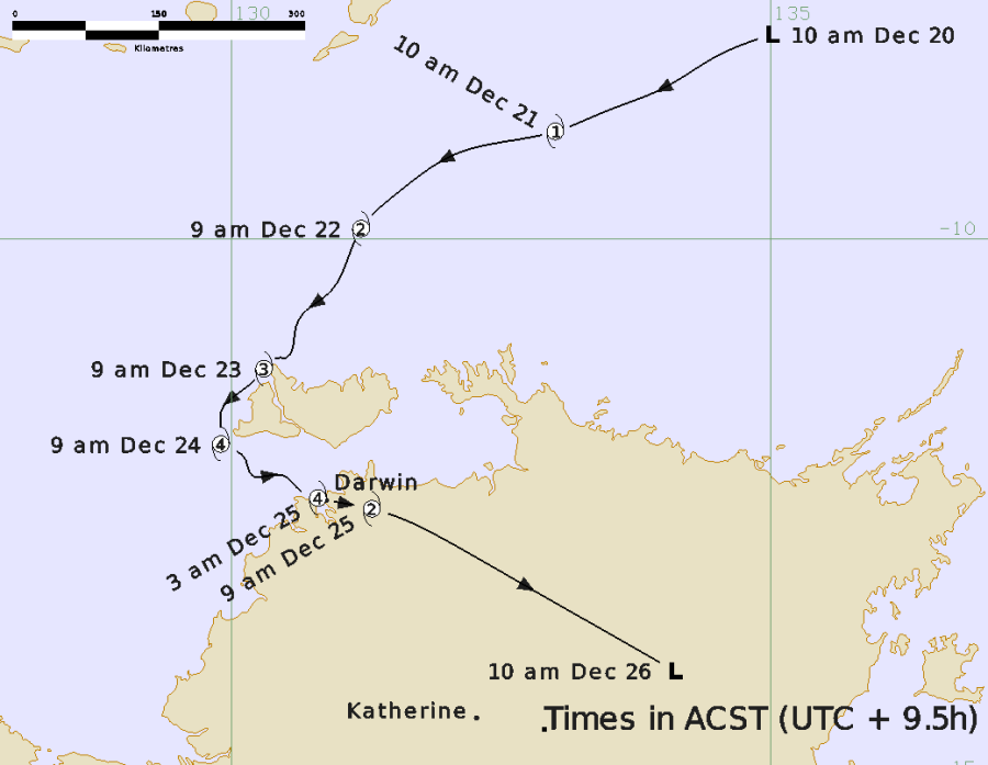
Severe Tropical Cyclone Marcus - 14 - 25 March 2018
Severe Tropical Cyclone Trevor - 17 – 28 March 2019
Severe Tropical Cyclone Claudia- 5 - 16 January 2020
Severe Tropical Cyclone Ilsa - 6 - 15 April 2023
Photo Caption: Forecast map. Source: Bureau of Meteorology
Alice Springs Flooding
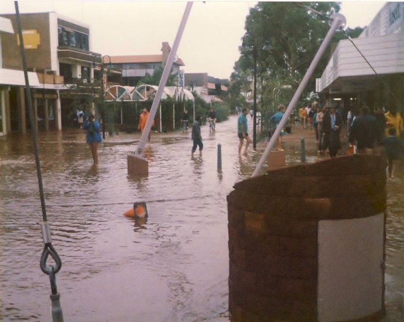
From 30 to 31 March 1988, the Todd River catchment in Central Australia saw the largest rainfall recorded within 24 hours. More than 300 mm of rain fell in the western MacDonnell Ranges, with over 150 mm at stations further east, around Alice Springs. The flood reached a gauge height of 3.98m.
The Todd River burst its banks, flooding large areas of Alice Springs, and isolating it from the south as road and rail links through Heavitree Gap were cut. Further south, the Hugh and Palmer Rivers also burst their banks, cutting the Stuart Highway.
- Read more
The weather system which caused the flood resulted from the combined effects of two tropical depressions, one forming to the north-east of Darwin, and the second in the Indian Ocean south of Java. The combined depression then travelled in a south-easterly direction to Alice Springs.
NTES assisted in the evacuation of approximately 300 people from low-lying areas. Despite these efforts, there were three fatalities in the floods.
NTES has responded to several other flooding events in Central Australia, including the flooding caused by Ex-Tropical Cyclone Ellie in January 2023, which crossed back into the Northern Territory from WA bringing heavy falls to the south-west and close to Alice Springs and isolating communities in the Timber Creek region.
Photo Caption: Alice Springs 1988 Floods - Todd Mall. Parsons Street
Katherine Flooding
On 24 January 1998, Tropical Cyclone Les developed over the Gulf of Carpentaria. As the cyclone reached land it weakened into a rain depression which moved towards Katherine.
- Read more
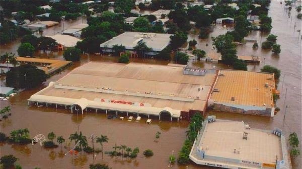
In Katherine, rainfall began on 25 January and continued steadily for three days. During this time between 400 and 500 mm fell over the Katherine, Roper and Daly River catchments. More than 30 people were injured and three people lost their lives in the floodwaters.
With rain continuing, by 27 January the Katherine River had risen to more than 20m, the main street was covered by two meters of muddy water.
A state of emergency was declared. Almost a quarter of the town's residents were evacuated to centres on higher ground, as the town went underwater. The community at Daly River was also affected by the flood as it moved downstream, with 400 people evacuated.
In the following months and years, a flood mitigation committee was formed, emergency services were relocated outside the floodplains, and the community improved its flood mapping.
The Katherine region has had its fair share of flooding events with NTES responding to several other flooding events in the region including the major flood in April 2006.
Photo Caption: The Katherine River rose to its highest level on record of 20.4 metres during the 1998 flood. (Supplied: Our Territory
Major Evacuation of Victoria Daly Region
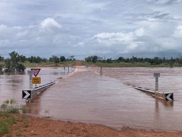
In the first week of March 2023, with the upper Victoria River exceeding major flood levels after persistent heavy rain in the region, evacuations were ordered for residents in the Victoria Daly Region of Northern Territory. Rain had already been falling in the area for a week, but intensified with Kalkarindji recording 134 mm of rain in 24 hours to and Lajamanu recorded 114 mm. The Victoria River at Kalkarindji stood at 16.99 metres, above the major flood stage of 14 metres.
- Read more
Australia’s Bureau of Meteorology reported rainfall recorded in the Upper Victoria River catchment had resulted in rapid river level rises and major flooding along the Victoria River at Kalkarindji with possible isolated heavier falls are forecast.
NTES assisted to evacuate almost 700, many who were airlifted from Kalkarindji, Daguragu and Pigeon Hole communities to be housed at the Centre for National Resilience at Howard Springs on the outskirts of Darwin.
Photo Caption: Major flooding at Sandy Creek
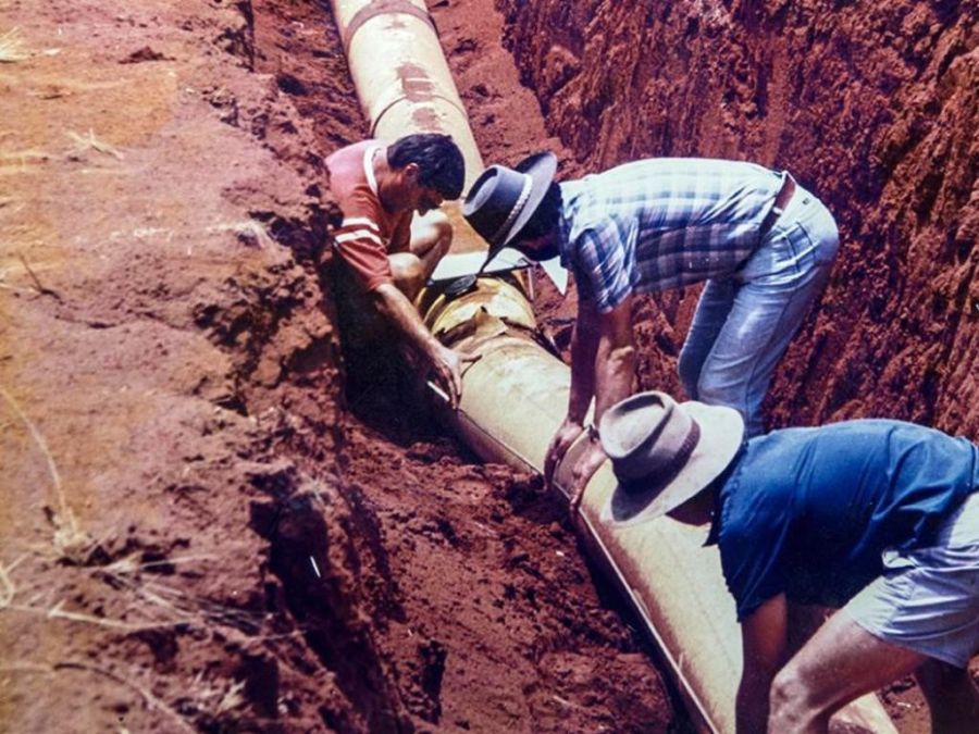
Tennant Creek Earthquake
It's more than 30 years since Australia's largest earthquake shook the town of Tennant Creek, with what locals described as a loud rumbling noise, a bit like a train passing. The first quake struck on the morning of 22 January 1988 at 10.05am and was followed by two stronger quakes later that day, the largest of which reached 6.6 on the Richter scale. Tremors continued throughout the Australia Day weekend.
- Read more
NT Volunteer Unit Officer Leslie Liddle was operational on the ground at the time and assisted to assess damage to buildings that despite the strength of the quakes was minimal. Tiles fell from rooftops, large cracks appeared in the earth and the major gas pipeline buckled requiring repair (pictured).
Photo Caption: Despite the strength of the earthquake, very little damage occurred. Photo: Geoscience Australia